XIII. Rethinking Neighborhood Walking Tours: How Augmented Reality Can Restore Historical Landscapes
- Jamie Carkenord, The George Washington University
In 2018, a New York City-based artist collective made headlines with their mobile phone app MoMAR, a program which asked visitors to the Museum of Modern Art (MoMA) to look through their phone cameras to view digital artworks overlaying the physical museum pieces. Using augmented reality (AR), the app projected tongue-in-cheek artistic commentary about pop culture and general museum snobbery on top of iconic artworks.1 The independent group branded themselves as an “unauthorized gallery concept aimed at democratizing physical exhibition spaces, museums, and the curation of art within them.”2 The Museum of Modern Art did not respond to what news outlets called a “hijacking,” or “takeover,” leaving the group to create multiple unauthorized exhibits since 2018. Describing the project, MoMAR spokesperson Damjanski said, “we literally are trying to claim the space.”3 This provocative demonstration attracted widespread media attention because it illustrated how augmented reality can be used as a tool to claim space and reframe mainstream narratives about arts and culture. It encouraged visitors to question what they saw and think critically about the cultural value of the works on display. Now, in the wake of international calls for social and racial justice, many museums have embraced new strategies for presenting content which challenges narratives of colonialism and white supremacy. Just as MoMAR attempted to democratize museum spaces using augmented reality, museums themselves are considering how AR could reshape the stories they tell.
While art museums have been utilizing AR in their galleries since the early 2010’s4, history and culture museums have also taken augmented reality to the streets through mobile apps which guide users on neighborhood walking tours featuring audio, video, and augmented reality content. As museums strive to attract younger, more diverse audiences, technology like AR presents an opportunity for digitally literate visitors to utilize their smartphones to access unexpected content or perspectives. Augmented reality also creates a unique relationship between physical and digital space, asking users to consider their own interactions with the spaces they inhabit. This particular element of AR offers new possibilities for history, culture, and community museums to demonstrate how significant locations change over time and influence society. In this paper I will present a brief definition of AR and explore how museums are using augmented reality to help the communities they serve reclaim space and alter local historical narratives. I will use recent examples from the Levine Museum of the New South and the Smithsonian Anacostia Community Museum as case studies to examine the benefits, drawbacks, and possibilities of augmented reality tours which re-center marginalized histories.
What is Augmented Reality (AR)?
Augmented reality is the integration of digital information with the user’s environment in real time. Using the device camera, visual elements and sound can be overlaid onto the device to create “an interwoven experience where digital information alters the user’s perception of the real world.”5 This technology allows the user to see through their phone camera as usual, with additional content like a photograph overlapping part of their screen. Most modern smartphones and tablets have the processing capability and hardware to utilize AR, making it relatively accessible to everyday users. Augmented reality can also make use of Global Position System (GPS) and digital compasses, meaning that it can identify where a user’s phone is located in geographical space and how the phone is oriented. Applications can then respond to augmented reality markers in the real world and show specific content depending on the user’s location.6 Readers may be familiar with this technology as it appeared in the popular 2016 app Pokémon GO. A more thorough history of AR and its technical capabilities and limitations, along with its implications for museum education and accessibility, can be found in this course’s 2019 and 2021 essay collections. This paper will focus on the use of AR outside of traditional exhibit spaces.
Possibilities for Historical Storytelling and Community Building
This kind of AR technology could be uniquely applicable to museum storytelling related to the local or national history of marginalized communities. In the United States, physical neighborhood landscapes have often changed significantly over time due to economic changes, government-imposed relocation, gentrification, and other issues specific to the area. This means that many important residential areas, gathering spaces, businesses, religious structures, and cultural centers which fueled the arts, activism, and community development do not remain standing as they did during their past periods of frequent use.
For AR applications, these locations create an interesting dynamic for museum content, because the significant spaces discussed in a tour may not be physically preserved and viewable. In contrast to museum exhibits that employ AR to provide additional information about physical artworks or artifacts, AR tours can recall images or other content from the past to provide context for a space which may not at first appear noteworthy. Rather than learning about significant historical events through exhibit content in a museum, AR users can immerse themselves in the actual location where things happened and reflect on how (and why) the landscape has changed over time.
Of course, historical place markers and plaques already abound in major cities, reminding locals and tourists alike of the meaningful stories that took place in everyday locations. But the addition of audio, visuals, and augmented reality asks users to examine their surroundings more closely. These elements can also prompt users to directly compare historical data with present conditions in order to actively draw their own conclusions, a critical aspect of historical learning.7 A 2015 study by a Taiwanese tourism and education research group asserts that “visitors perceive AR guidance activities as interesting, fun, challenging, and a method of achieving first-hand experience.”8 An AR application may also provide a more immersive experience and “increase people’s motivation to visit and learn.”9 A common critique of AR programs is the incentive for users to pay more attention to their phones than their physical surroundings,10 but an integrated walking tour encourages users to actively observe the landscape around them. Additionally, by taking place outside of a museum, this kind of tour doesn’t detract from the experience of looking at and learning from the physical objects on display in museum collections. The following case studies explore how two history museums have approached using AR programs in their local communities to expand their neighborhood presence and contribute to collective community memory.
KnowCLT: An AR Walking Tour from the Levine Museum of the New South
In August 2021, the Levine Museum of the New South released a free app called KnowCLT, which guides users on a walking tour through the historic Brooklyn neighborhood of Charlotte, North Carolina. The app features an audio tour and augmented reality content which projects historic photographs over the user’s phone camera. Brooklyn, the thriving Black business district of the early twentieth century, was largely demolished in the 1960’s in a city-led urban renewal program. Through KnowCLT, the Levine Museum hopes to “resurrect…significant places and see them where they once stood.”11 See the app in action and learn more about its development here.
The Levine Museum walking tour is deeply rooted in community stories. Black and white photographs restore historic businesses, churches, and schools to the landscape through AR. At each stop, users can listen to short oral histories recalling memories from that location, told by the former residents themselves. This means that multiple perspectives and experiences are represented in the tour, creating a more complete narrative. The KnowCLT app also engages with the present-day community in Charlotte. In the app, users can publicly comment on chapters of the audio tour or oral history segments. Comments like “love the photos” and “my mother grew up here” provide feedback on the app experience and enrich the stories being told. Users sometimes recognize oral history storytellers and express their affection and admiration through the comments feature. Engagement such as commenting, liking other’s comments, and sharing parts of the tour on social media is easy and encouraged in KnowCLT. The app even rewards this kind of engagement with links to coupons for local Black-owned businesses.12
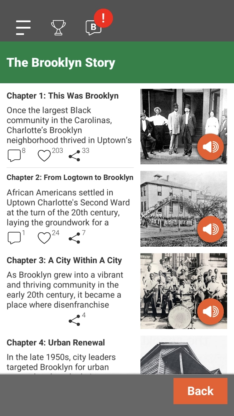 Figure 1
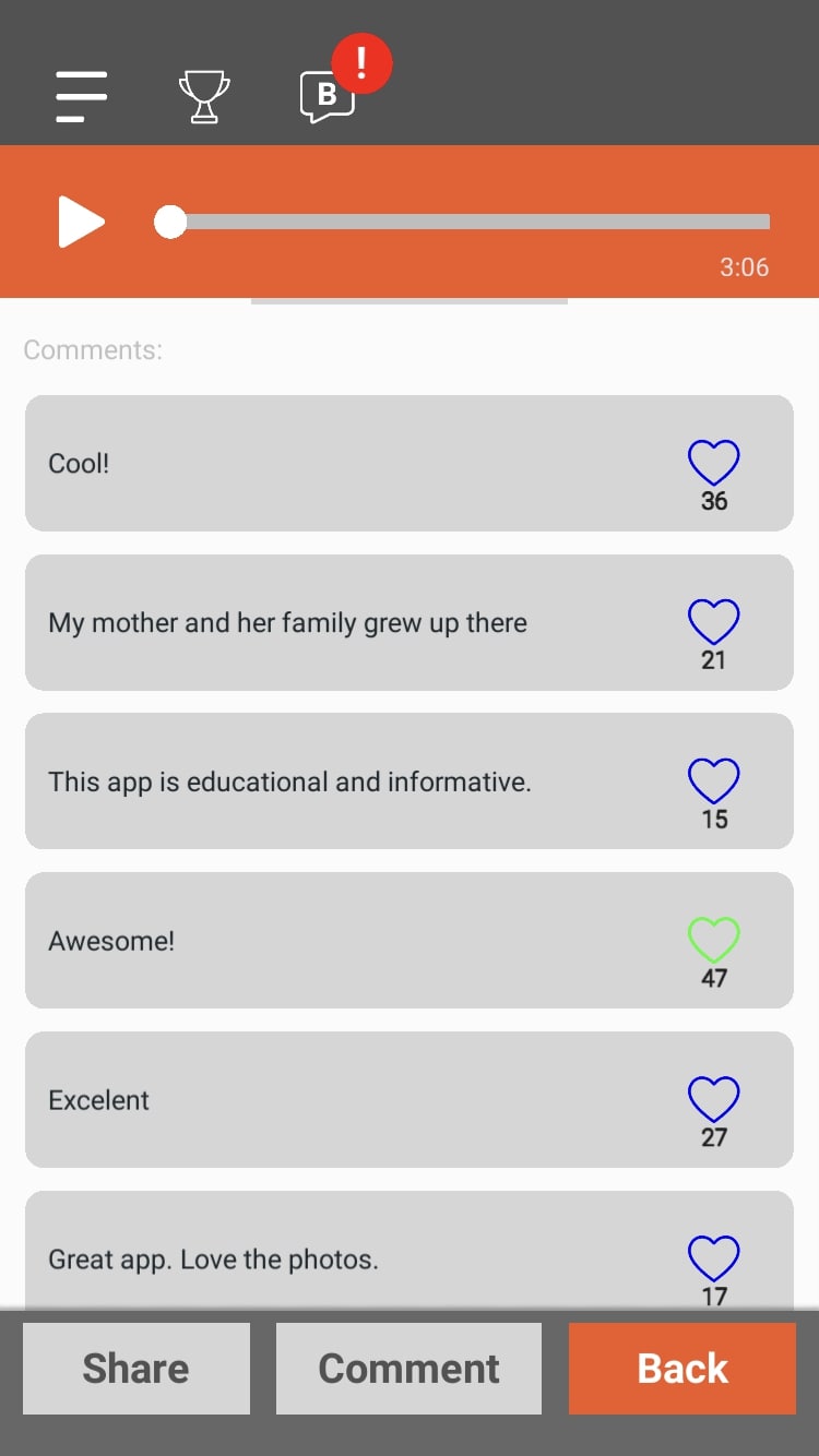 Figure 2
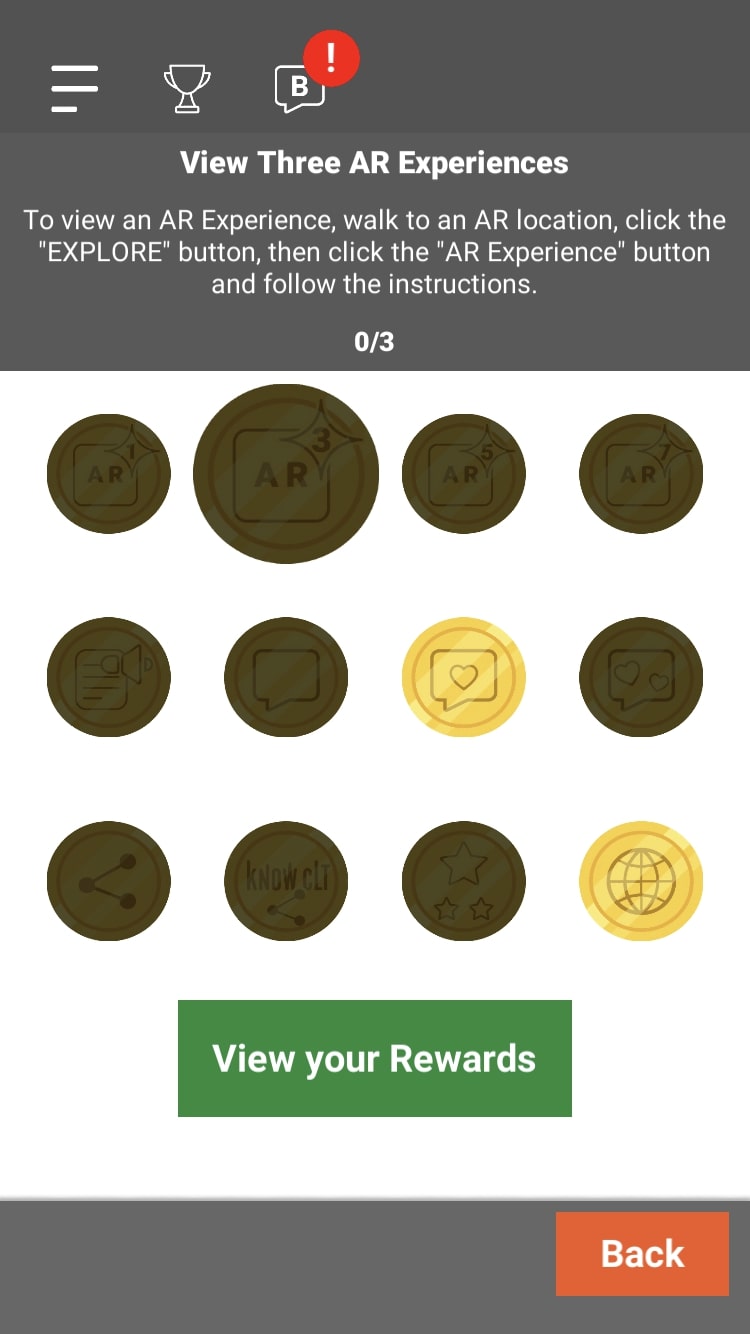 Figure 3
The KnowCLT app is a great example of a digital walking tour which creates an immersive experience. It offers multiple ways to engage with content—images, full text transcripts, audio, augmented reality, and interactive commenting—which facilitates an accessible and customizable experience. The Levine Museum and the City of Charlotte also installed physical signs, QR codes, and sidewalk markers at each of the seven augmented reality stops to inform passerby about the app. By including thoughtful details like first-person oral histories in addition to the augmented reality content, the KnowCLT app strategically uses digital technology to provide users with a visual and emotional connection to the past.
Before the Bulldozers: The Smithsonian Anacostia Community Museum AR Tour
This past October, the Smithsonian Anacostia Community Museum (ACM) launched a free app which guides users through a walking tour of Southwest Washington, DC. Once at the Waterfront Metro Station, the starting point for the tour, participants can use their mobile devices to orient themselves within the neighborhood, view images, and listen to audio content as they travel through a historic African American community. Three-dimensional visual content exists in 360 degrees, prompting viewers to turn about and step closer to images that interest them. Although the tour is designed to take about 45 minutes, users can spend as much time as they’d like at each stop, replaying audio or observing their surroundings. For those interested who cannot travel to DC, an online video version of the tour is available.
The focus of the tour is the federal urban renewal of Southwest DC in the 1950s, which aimed to “upgrade” the neighborhood and support development, but ultimately displaced over 20,000 African Americans whose families had lived and worked in the area for generations. As a result, the Southwest DC that exists today is “unrecognizable to former residents.”13 Combining resident oral histories with images from African American photographer and Southwest resident Joseph Owen Curtis, the tour is intimately connected with the authentic storytelling of the residents who were displaced. Director of the Anacostia Community Museum Melanie Adams stated,
Before the Bulldozers gives audiences eyes and ears to the historic stories that shaped Washington, DC. By moving through the Southwest neighborhood, seeing how the area changed and learning at whose cost those changes came to be, audiences better understand the role housing inequity plays out in everyday life—in DC and beyond.14
The Before the Bulldozers project is part of ACM’s year-long feature on housing injustice, titled “Our Housing, Our Future,” which focuses on racial inequality and includes community programs and educational partnerships.15
Experiencing Before the Bulldozers
I was eager to take this new tour myself and see how the app and audiovisual materials function, and I was largely impressed. The app was easy to navigate, and the tour starts at the Waterfront Metro stop, which made it easy to access and get oriented. On the whole, this was basically an audio tour, featuring walking directions and narration from multiple actors portraying historic characters. There was much less augmented reality content than I was expecting, but the storytelling was clear, informative, and engaging. The lead narrator served as a guide who contextualized quotes from historical documents and oral histories.
The tour effectively connected me with the physical landscape and provided insight into how urban planning and architecture can direct daily social life. Walking through the Southwest neighborhood helped me to understand these concepts in a way that wouldn’t be possible in a museum gallery space. I felt that the pacing and directions were especially well executed. The audio tour pointed out notable visual landmarks and street names enough that I almost always ended up in the correct location, and never felt lost. Additionally, while I listened to the story of Southwest’s development, I was simultaneously immersed in the community as it exists today. As I walked past businesses, churches, and schools, I saw community postings about local politics and aid initiatives which informed my perception of the neighborhood alongside the history I was hearing. The tour also introduced me to the Southwest Neighborhood Public Library, a present-day resource for education and internet access.
 Figure 4
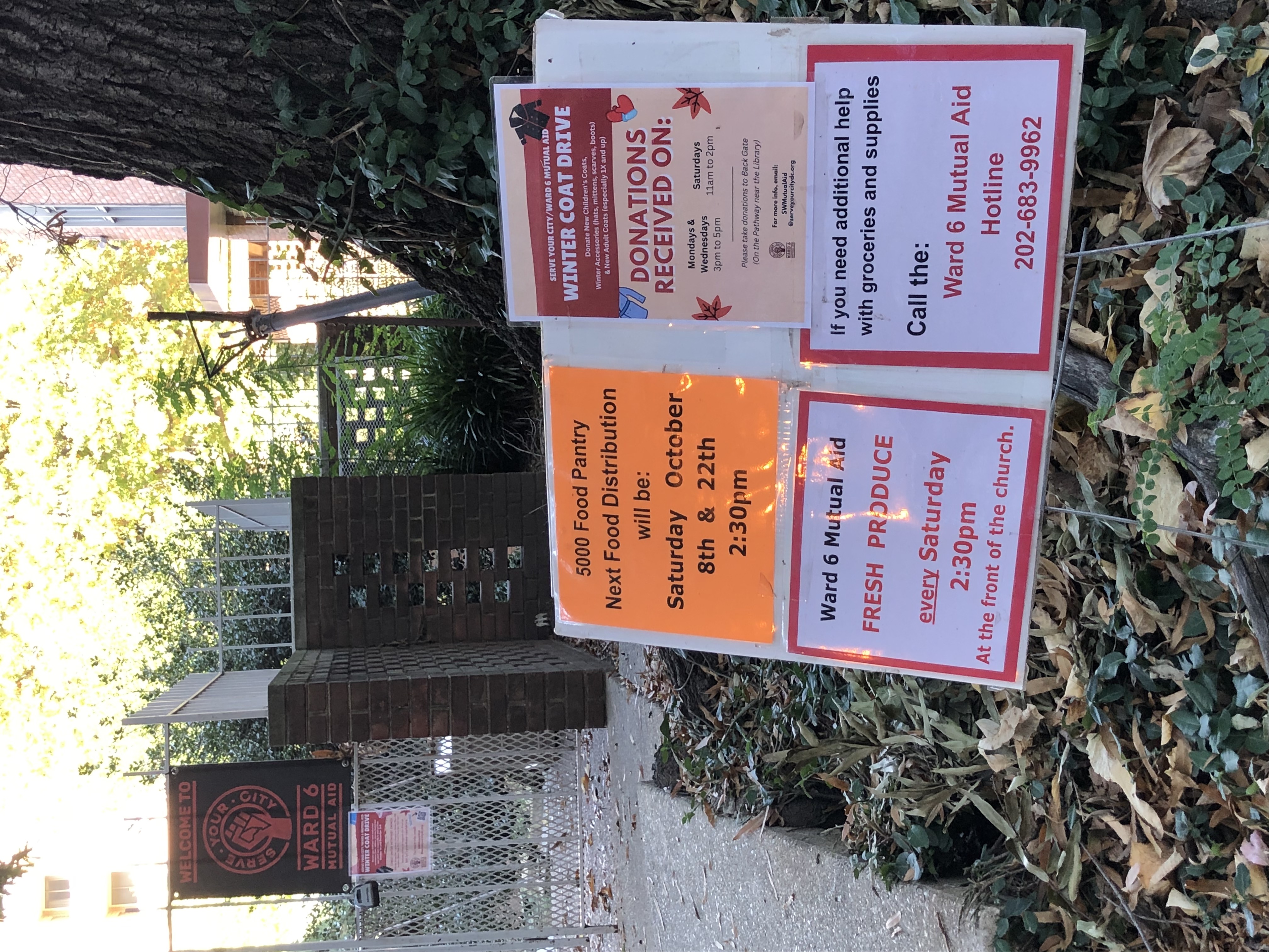 Figure 5
One particular strength of the tour was the guided interactions with physical and print materials. Inside the Southwest Neighborhood Public Library, the listener is directed to pull a copy of a historical document off the shelves and read along with the narrator. I thought this was a great way to incorporate interactive elements into the tour, while at the same time making users aware of the resources available in the library. I was also pleasantly surprised by a mini exhibit in the library, which the audio tour guided me through. A gallery wall displayed photographs taken by 20th-century African American photographer Joseph Owen Curtis—the same photographs used to inform the tour. After walking through Curtis’s neighborhood and hearing his words on the tour, seeing the physical print photographs themselves (and Curtis’s handwritten notes) was a powerful experience. The impact of the photographs was significantly elevated within the context of the walking tour. This small exhibit represents an effective collaboration between the Smithsonian Anacostia Community Museum and DC Public Libraries, and the audio tour led me to resources that I might have otherwise missed.
An additional note: the library offers public restrooms and water fountains, so including the library also makes these facilities available during the tour.
 Figure 6
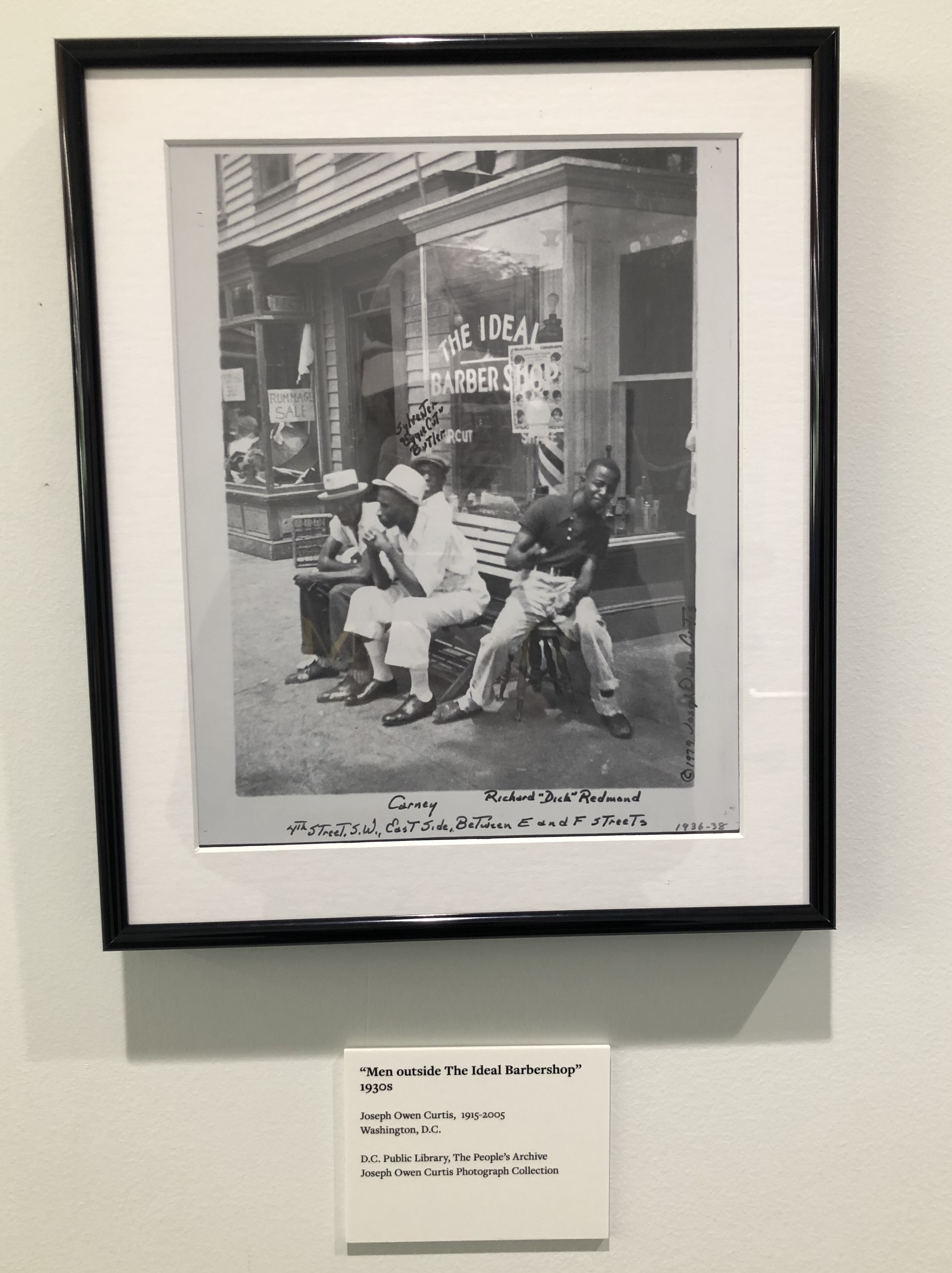 Figure 8
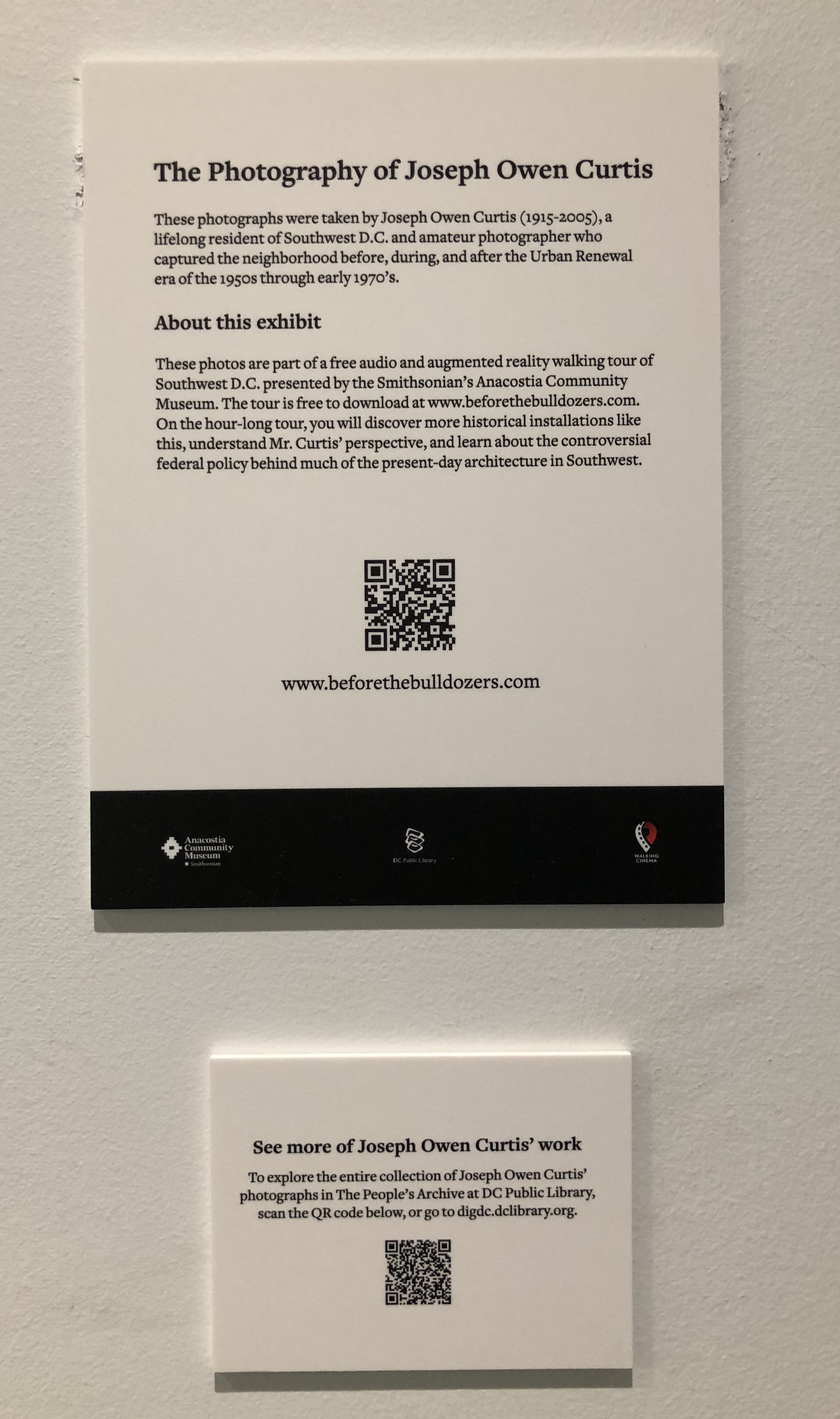
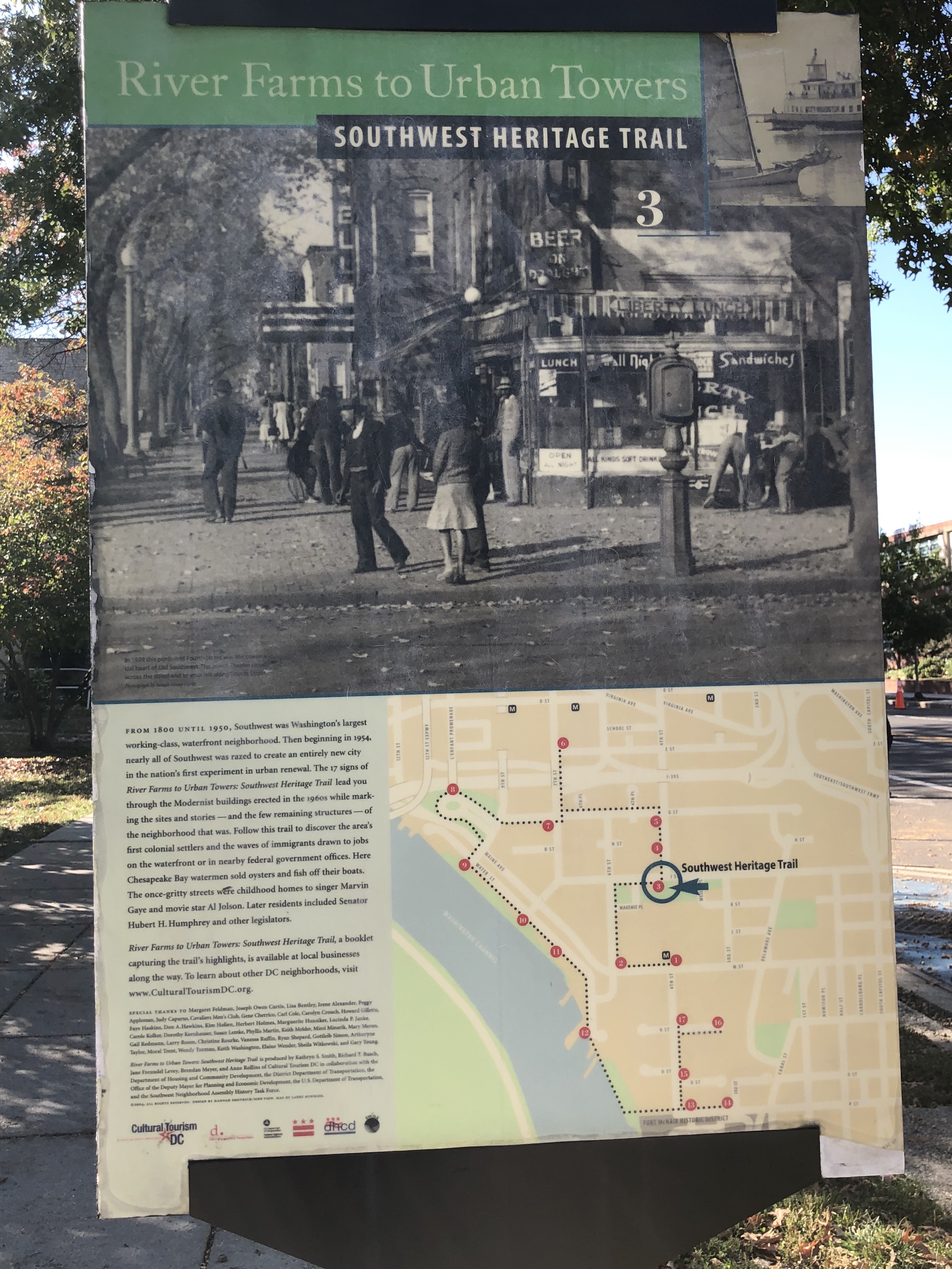
Outside of the library, the audio tour also engaged with physical Southwest Heritage Trail signs on several street corners. The lead narrator spoke about what these signs mean to those who used to live in the neighborhood or currently reside there. She says, “without the whole story, [these photos] …may land as quaint, nostalgic, markers of a lost time long ago. But now, I can’t help but find them markers of a systemic and traumatic displacement.”16 The audio guide recontextualized the signs and introduced important questions about how we learn about history, which added a critical nuance to the tour.
The weakest and ultimately most disappointing feature of the Before the Bulldozers tour was the augmented reality itself. Only three out of fourteen stops included AR content, and only one of those stops featured historic photographs overlaid on my device screen. The other two AR portions presented doodle-esque sketches on top of physical photographs displayed in the library and Heritage Trail signs. I was slightly surprised by the limited amount of AR content, because the tour was advertised as an Augmented Reality Tour. When I did use the AR feature, I also encountered a few issues. At the first AR stop, I was instructed to stand in the middle of a wide sidewalk, hold up my phone, and turn about to see photographs placed in 360 degrees. Although the augmented reality started automatically without any glitching, I had trouble seeing the small black-and-white images on my phone screen due to glare caused by the afternoon sun. I took the tour on a Friday afternoon, when the area was relatively busy, which also made me feel a bit awkward during this stop—I didn’t want bystanders thinking I was filming them. At the other two AR stops, I watched city plans and landmarks be “drawn” on top of photographs, which added a novel visual element, but lacked detail. As I finished the tour, I felt that it would have been just as effective without the AR elements. The quality of the augmented reality portions simply didn’t compare with the audio script. In this case, augmented reality unfortunately appeared to be used more as an attention-grabbing buzzword than as a thoughtful storytelling technique.
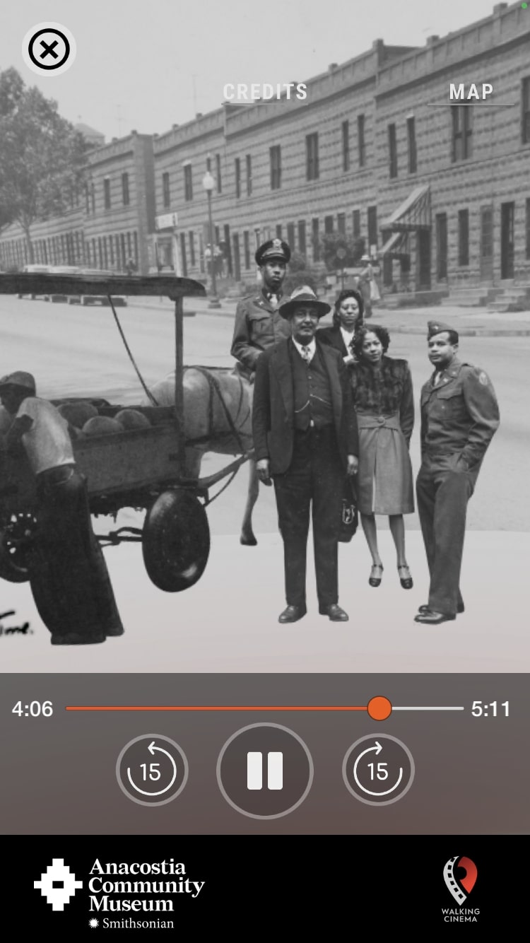 Figure 11
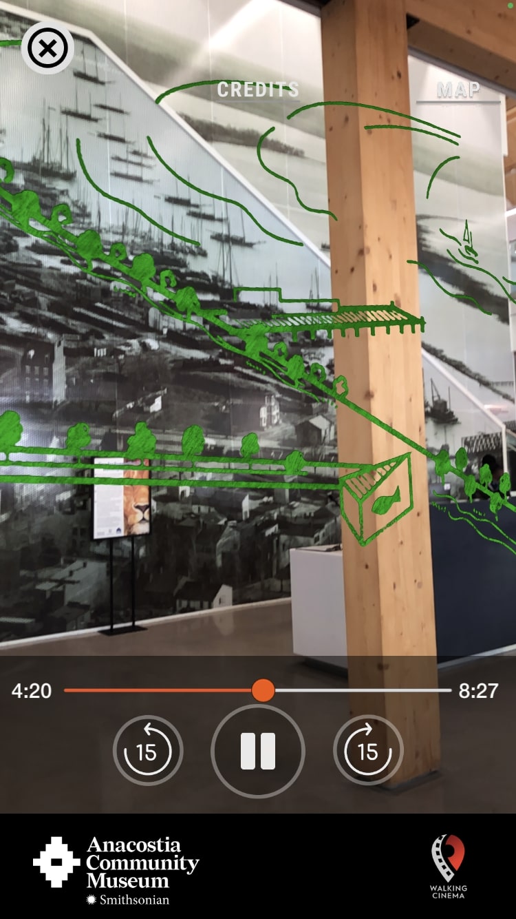 Figure 12
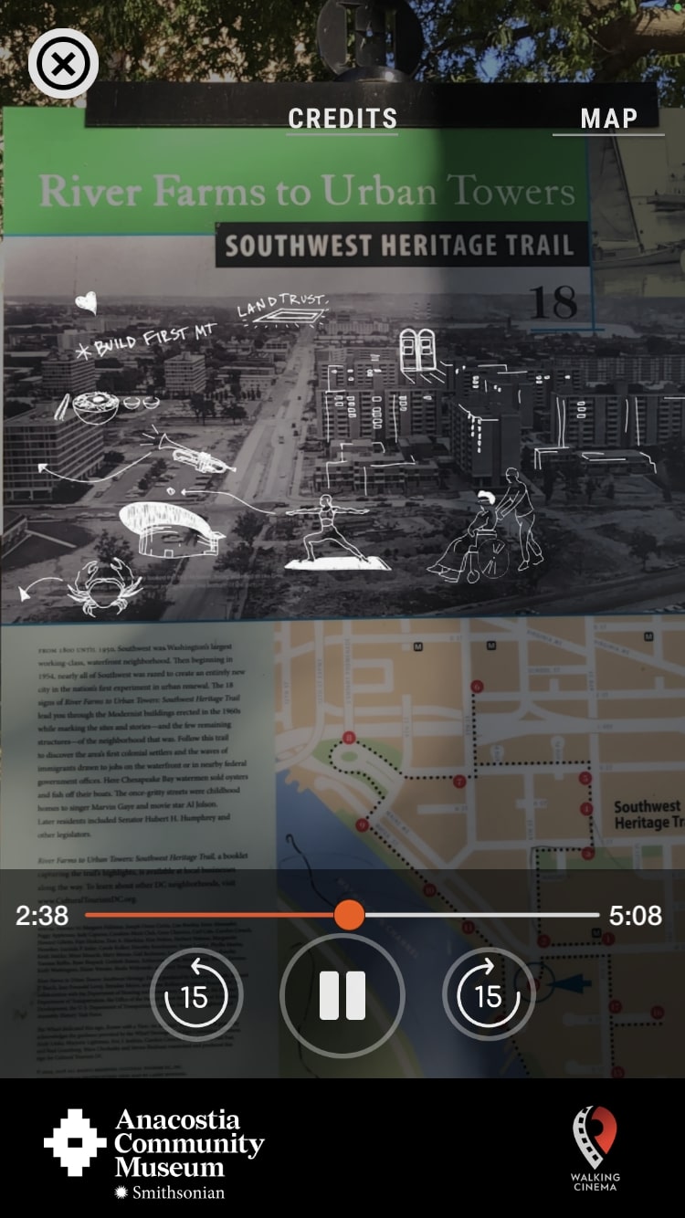 Figure 13
Conclusion: Room to Grow
Although the Before the Bulldozers augmented reality was disappointing, I was still impressed with the overall experience, because it introduced me to both a new local history as well as a new kind of place-based learning. The Smithsonian Anacostia Community Museum’s tour app demonstrates several of the current challenges of outdoor augmented reality, such as unpredictable busy times and weather conditions. Although the app itself functioned effectively, the AR portions came off as gimmicky. Based off of the content I was able to access remotely from the Levine Museum KnowCLT app, I feel that it more effectively integrated augmented reality content into its program. Augmented reality technology is relatively common right now and presents real potential for digitally restoring historic landscapes, but in practice, it must be used thoughtfully in order to effectively add to a narrative.
Augmented reality aside, my case studies illustrated other significant strategies for digital storytelling. Walking tour apps allow individuals to discover history for themselves, independently, and on their own time. Digital content facilitates the inclusion of many diverse perspectives within conversations about local history and memory. Rather than remaining permanent and unchanged like a physical historical marker, mobile apps can be consistently updated and adapted as researchers uncover new information and the public expresses feedback. The “comment and share” section of the KnowCLT app also demonstrates modern museums' understanding that the public can play an active role in sharing their local history. These kinds of apps encourage digital engagement with local history during the tour and beyond, creating long-term impact. Over time, I expect that traditional historical markers will continue to be updated with QR codes or information about supplemental digital content. History museums will likely continue to explore augmented reality as a tool for illustrating significant changes in neighborhood landscapes, especially because AR can gain the attention of news media (and folks interested in new tech). As museums attempt to connect to their local communities in relevant, accessible ways, digital walking tours can continue to provide innovative and immersive experiences beyond gallery walls.
Notes
-
Drew Zelba, “Curatorial collective augments MoMA with an AR exhibition,” *The Architects Newspaper*, December 9, 2019, https://www.archpaper.com/2019/12/curatorial-collective-augments-moma-momar/. ↩︎
-
MoMAR, “About,” MoMAR, accessed October 12, 2022, https://momar.gallery/about.html. ↩︎
-
Mack DeGuerin, “Internet Artists Invaded the MoMA With A Guerilla Augmented Reality Exhibit,” Vice, March 5, 2018, https://www.vice.com/en/article/8xd3mg/moma-augmented-reality-exhibit-jackson-pollock-were-from-the-internet. ↩︎
-
Shelley Mannion, “Beyond Cool: Making Mobile Augmented Reality Work for Museum Education,” *Museums and the Web 2012,* October 13, 2012. ↩︎
-
Alexander S. Gillis, “Definition: augmented reality,” Techtarget.com, accessed October 12, 2022, https://www.techtarget.com/whatis/definition/augmented-reality-AR. ↩︎
-
Alexander S. Gillis, “Definition: augmented reality,” 2022. ↩︎
-
Jason M. Harley, et al, “Comparing Virtual and Location-Based Augmented Reality Mobile Learning: Emotions and Learning Outcomes,” *Educational Technology Research and Development* 64, no. 3 (2016): 359–88, http://www.jstor.org/stable/24761376. ↩︎
-
Yu-Lien Chang, et al., “Apply an Augmented Reality in a Mobile Guidance to Increase Sense of Place for Heritage Places,” *Journal of Educational Technology & Society* 18, no. 2 (2015): 167, http://www.jstor.org/stable/jeductechsoci.18.2.166. ↩︎
-
Ibid. ↩︎
-
Ibid. ↩︎
-
Jessica Dyer, “’Almost like a time machine or the closest thing we can get to it’: New app gives immersive history of Charlotte,” WBTV, August 5, 2021, https://www.wbtv.com/2021/08/06/almost-like-time-machine-or-closest-thing-we-can-get-it-new-app-gives-immersive-history-charlotte/. ↩︎
-
Levine Museum of the New South, KnowCLT Mobile App, 2021. ↩︎
-
Madeleine Weyand-Geise and Katelynd Anderson, “Anacostia Community Museum Launches Augmented-Reality Tour of Southwest D.C.,” Smithsonian, October 4, 2022, https://www.si.edu/newsdesk/releases/anacostia-community-museum-launches-augmented-reality-tour-southwest-dc. ↩︎
-
Ibid. ↩︎
-
Ibid. ↩︎
-
Anacostia Community Museum, *Before the Bulldozers* Mobile App, Chapter 10, 2022. ↩︎